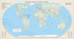
Ekvivalentna Zemljina kartografska projekcija
The Equal Earth map projection is used here to depict the political geography of the world. The projection was developed in 2018 by Bojan Šavrič, Tom Patterson, and Bernhard Jenny, and subsequently used by cartographer Tom Patterson to produce a political world map. Equal Earth has attracted particular attention in African countries because, as an equal-area projection, it preserves the relative sizes of continents and other geographical areas. The African Union subsequently endorsed the #CorrectTheMap campaign, and in 2026 Togo introduced a resolution in the United Nations General Assembly recommending the use of the new projection for maps depicting the world as a whole.
The resolution was adopted by a large majority of UN Member States. The political world map uses standardized Slovenian names for countries and dependent territories, together with established Slovenian exonyms. For geographical names originally written in non-Latin scripts, the authors of the Slovenian edition applied the transliteration rules prescribed by Pravopis 8.0.
Downloads
License

This work is licensed under a Creative Commons Attribution-ShareAlike 4.0 International License.